
TOP DESTINATIONS

Brief synthesis
The Petroglyphic Complexes of the Mongolian Altai include three rock art sites in Bayan-Ulgii aimag: Tsagaan Salaa-Baga Oigor of Ulaankhus soum, and Upper Tsagaan Gol (Shiveet Khairkhan) and Aral Tolgoi, both of Tsengel soum. All three are located in high mountain valleys carved out by Pleistocene glaciers. These three property components include large concentrations of petroglyphs and funerary and ritual monuments reflecting the development of human culture over a period of 12,000 years. The persistent relationships between rock art, surface monuments and the larger physical context of rivers, ridges and cardinal directions create a vivid sense of the integration of human communities with the land they inhabited.
The earliest images reflect a period beginning in the Late Pleistocene and lasting through the Early Holocene (ca. 11,000 – 6,000 years BP), when the paleoenvironment shifted from dry to forested steppe and the valleys provided an ideal habitat for hunters of large wild game. Later images from the middle Holocene (ca. 6,000 – 4,000 years BP) reflect the gradual reassertion of steppe vegetation in this part of the the Altai and the early emergence of herding as the economic basis of communities. Imagery from the succeeding, Late Holocene Period, reflects the transition to horse-dependent nomadism during the Early Nomadic and Scythian periods (1st millennium BCE) and the subsequent spread of steppe empires in the later Turkic Period (7th-9th c. CE).
The Petroglyphic Complexes of the Mongolian Altai represent the most complete and best preserved visual record of human prehistory and early history of a region at the intersection of Central and North Asia.
Criterion
The Petroglyphic Complexes of the Mongolian Altai Mountain provide an exceptional documentation of the pre-historic and early historic communities in the northwestern Altai Mountains, at the intersection of Central and North Asia. The petroglyphic imagery includes animals such as mammoths, rhinoceros, and ostriches, executed in static profile contours. These animals inhabited North Asia when the region was significantly colder, drier and covered by rough grasses and forbs rather than forests. By the end of the Late Pleistocene (ca. 11,000 BP), the dry steppe was gradually being replaced by the forested environment of the Early Holocene (ca. 11,000 – 6,000 BP). This period is reflected in majestic images of elk, aurochs, and ibex, executed in profile silhouettes. There are very few sites in North Asia that include pre-Bronze Age petroglyphs in such number, variety, and quality.
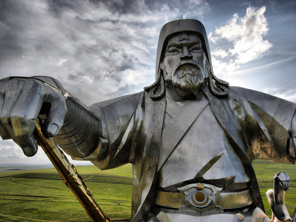


The Genghis Khan Equestrian Statue, part of the Genghis Khan Statue Complex, is a 40-metre (130 ft) tall, stainless steel statue of Genghis Khan on horseback and the world’s tallest equestrian statue. It is located on the bank of the Tuul River at Tsonjin Boldog, 54 km (33.55 mi) east of the Mongolian capital Ulaanbaatar, where, according to legend, he found a golden whip.
The statue is symbolically pointed east towards his birthplace. It is on top of the Genghis Khan Statue Complex, a visitor centre, itself 10 metres (33 ft) tall, with 36 columns representing the 36 khans from Genghis to Ligdan Khan. It was designed by sculptor D. Erdenebileg and architect J. Enkhjargal and erected in 2008.
Visitors walk to the head of the horse through its chest and neck, where they have a panoramic view. The main statue area will be surrounded by 200 ger (yurts), designed and arranged like the pattern of the horse brand marks that were used by the 13th century Mongol tribes. The cost of the complex is reported to be US$4.1 million, built by The Genco Tour Bureau, a Mongolian company.
The attached museum has exhibitions relating to the Bronze Age and Xiongnu archaeological cultures in Mongolia, which show everyday utensils, belt buckles, knives, sacred animals, etc. and a second exhibition on the Great Khan period in the 13 and 14th centuries which has ancient tools, goldsmith subjects and some Nestorian crosses and rosaries. Adjacent to the museum is a tourist and recreation centre, which covers 212 hectares (520 acres).
Overview
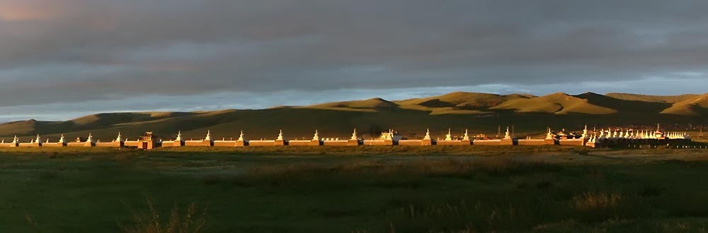
The Erdene Zuu Monastery (Mongolian: Эрдэнэ Зуу хийд, Chinese:光顯寺, Tibetan:ལྷུན་གྲུབ་བདེ་ཆེན་གླིང་) is probably the earliest surviving Buddhist monastery in Mongolia.
Located in Övörkhangai Province, approximately 2 km north-east from the center of Kharkhorin and adjacent to the ancient city of Karakorum, it is part of the Orkhon Valley Cultural Landscape World Heritage Site.
The monastery is affiliated with the Gelug sect of Tibetan Buddhism.
History
Abtai Sain Khan, ruler of the Khalkha Mongols and grandfather of Zanabazar, the first Jebtsundamba Khutuktu, ordered construction of the Erdene Zuu monastery in 1585 after his meeting with the 3rd Dalai Lama and the declaration of Tibetan Buddhism as the state religion of Mongolia.
Stones from the nearby ruins of the ancient Mongol capital of Karakorum were used in its construction.
Planners attempted to create a surrounding wall that resembled a Tibetan Buddhist rosary featuring 108 stupas (108 being a sacred number in Buddhism), but this objective was probably never achieved.The monastery’s temple walls were painted, and the Chinese-style roof covered with green tiles.
The monastery was damaged in 1688 during one of the many wars between Dzungars and Khalkha Mongols. Locals dismantled the wooden fortifications of the abandoned monastery. It was rebuilt in the 18th century and by 1872 had a full 62 temples and housed up to 1000 monks.
According to tradition, in 1745, a local Buddhist disciple named Bunia made several unsuccessful attempts to fly with a device he invented which was similar to a parachute.

Ongi Monastery (Mongolian: Онгийн хийд, Ongiin Khiid) is the collective name for the ruins of two monasteries that face each other across the Ongi River in Saikhan-Ovoo district of Dundgovi Province, in south-central Mongolia.
The Barlim Monastery is located on the north bank of the river while the Khutagt Monastery sits on the south bank. The older southern complex consisted of various administrative buildings as well as 11 temples.
The northern complex, built in the 18th century, consisted of 17 temples – among them one of the largest temples in all of Mongolia. The grounds housed also 4 Buddhist universities.
Founded in 1660, it was one of the largest monasteries in Mongolia and housed over 1000 monks at its height. The ruins are situated about 18 km south of the town of Saikhan Ovoo.
Both complexes of Ongi Monastery were completely destroyed in 1939 during anti-religious purges carried out under Khorloogiin Choibalsan, the leader of the Communist Party of Mongolia. Over 200 monks were killed, and many surviving monks were imprisoned or forcibly laicized and conscripted into the Communist controlled army.
A large number of ruins including a tall stupa can be seen on the river and on the surrounding hills. In the 1990s, it was decided to rebuild the monastery. The first temple was inaugurated in 2004. There is a small museum in a ger in front of it.
One of the stupas has just been reconstructed as well. It has a commemorative plaque indicating the names of the monks who were killed in 1939.
Location
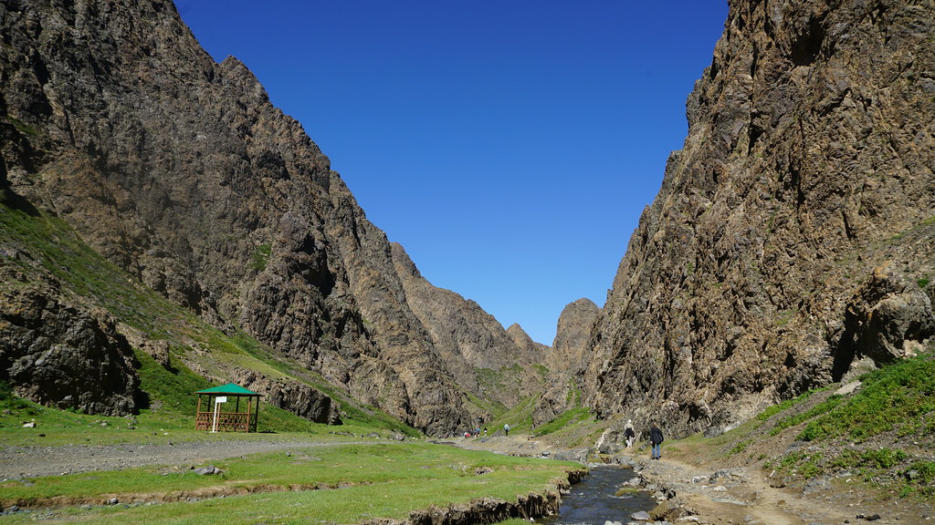
Yol valley is located 56 km from Dalanzadgad city. Features: It is the deep, narrow mountain gorge (valley) in Gobi Gurvan Saikhan Mountain. This gorge is 2800m above sea level, covers about 64 sq km area, about 40 km long and up to 200 meters high.
Discover beautiful Yolyn Am or also known as Yol Valley (translates to Lammergeier Gorge or Lammergeier Valley) located in the Gobi Gurvan Saikhan National Park. Very wide at the entrance, it narrows gradually into a remarkable gorge.
Ice formed by a brook is visible even in summer (until the end of July) and tourists admire the mountain sheep and goats on the almost vertical slopes.

Location:
660 km from Ulaanbaatar, 180 km northwest of Tsetserleg town, and just 4 km from Tariat soum (administrative unit) of Arkhangai province.
The Horgo (Mongolian: Хорго) is a volcano in the Taryatu-Chulutu volcanic field in the Tariat district in the Arkhangai Province of Mongolia.
The Horgo lies east of the lake Terkhiin Tsagaan Nuur and together they are the core of the Khorgo-Terkhiin Tsagaan Nuur National Park.
A notable geological feature are solidified lava bubbles, which the locals have named “basalt yurts”.